


hermet

bouscaillou
User
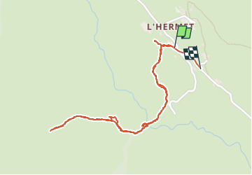

Length
2.6 km

Max alt
1075 m

Uphill gradient
113 m
Km-Effort
4.1 km

Min alt
997 m

Downhill gradient
111 m
Boucle
Yes
Creation date :
2023-05-01 14:30:56.715
Updated on :
2023-05-01 15:37:40.903
1h06
Difficulty : Easy

FREE GPS app for hiking
 SityTrail
IGN / Geographical institutes
SityTrail Plus
The world is yours!
About
Trail Walking of 2.6 km to be discovered at Occitania, Lozère, Pont de Montvert - Sud Mont Lozère. This trail is proposed by bouscaillou.
Positioning
Country:
France
Region :
Occitania
Department/Province :
Lozère
Municipality :
Pont de Montvert - Sud Mont Lozère
Location:
Le Pont-de-Montvert
Start:(Dec)
Start:(UTM)
557928 ; 4910916 (31T) N.
Comments